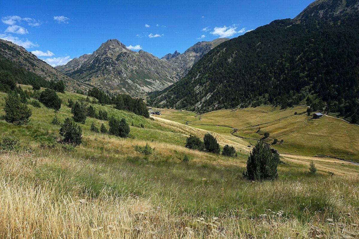
I have a photograph from my first afternoon in Vall d’Incles that I still look at more than it deserves. Two horses, knee-deep in grass, a river doing lazy S-bends across a valley floor as flat as a runway, and grey granite walls closing in on three sides. It is the most obviously beautiful place in Andorra, and the country knows it, which is why in high summer they will not let you drive up it.
This guide covers Vall d’Incles from the road head to the border ridge: the summer shuttle that replaces private cars, the walk to the Juclar lakes, Cabana Sorda, Siscaro, timings and ascent in real numbers, and whether it is worth your day. It is written for walkers of all levels, including families with small children.
Last updated: September 2026. Times, prices, shuttle schedules and bus timetables change every season – check the Canillo parish and Visit Andorra sites before you set out.
Where Vall d’Incles is, and why it looks the way it does
The turning is easy to miss. Driving the CG-2 up towards the Port d’Envalira, somewhere between El Tarter and Soldeu, a small road drops right, crosses the Valira d’Orient and immediately starts climbing north into what looks like a wooded slot. Three kilometres later the slot opens out and you understand what the fuss is about.
A glacier did this. It ground north to south down the fault, scooped out the floor, dumped the debris and left behind a classic U-shaped trough with a river meandering across a flat alluvial bottom. That flatness is the whole point. Almost nowhere else in Andorra can you walk for twenty minutes on the level at 1,850 m with 2,700 m peaks on either shoulder.
Getting your bearings at the road head
The tarmac ends at the Bordes d’Incles, a scatter of stone barns that were once summer cattle shelters and are now, in several cases, very desirable second homes. There is a small seasonal tourist kiosk here in summer, a restaurant or two, and the start of every walk in this article.
From the barns the valley runs north for another kilometre and a half of level meadow before the trails split. Left and up for Juclar. Right and up for Siscaro. The Cabana Sorda path leaves earlier, from a spring called the Comellassos about halfway along the road, which catches out a lot of people who ride the shuttle straight to the top.
The Vall d’Incles summer shuttle, the road closure and where to park
This is the single thing most guides get wrong or skip, so here it is properly.
When private cars are restricted
In peak summer – broadly mid-June to mid-September, though the exact dates shift each year – private motor vehicles are not allowed up the Incles road during the day. The restriction I have seen posted runs roughly 10:00 to 18:00, and it exists because the road is single-track with almost nowhere to pass and the parking at the top was being overwhelmed by about half past nine every morning.
Outside those hours, and outside the season, you can drive up and park at the road head for free. This is exactly why the valley at seven in the morning is a different country from the valley at eleven.
What the shuttle actually is
It is marketed as a train and it is really a small electric road tractor towing open carriages. It shuttles between the paid car park at the valley entrance and the Bordes d’Incles, takes somewhere between five and ten minutes, and costs around EUR 3 each way. Young children generally travel free.
Service has run daily from about 09:00 to 18:00 in the summer months in recent seasons. Do not plan a long day around catching the last one back down: if you are walking to Juclar and lingering at the refuge, assume you may be walking the road at the end, which is a flat and entirely painless half hour.
The car park at the entrance is a paid blue zone. Bring coins or expect to use the machine’s card reader, and note that in August it fills up too – by mid-morning cars start lining the verge on the main road, which is neither legal nor popular with the parish.
Arriving by bus
You do not need a car. The national bus lines that run up the Valira d’Orient valley from Andorra la Vella towards Soldeu, El Tarter and Pas de la Casa stop at the mouth of the Incles road. The ride from the capital is around 30 to 40 minutes and the fare is a few euros. From the stop it is a short walk to the shuttle car park.
Check the current line numbers and timetable before you go rather than trusting any blog, including this one – the routes get renumbered. Our guide to getting around Andorra without a car covers how the national network works and where it lets you down.
Driving it in the shoulder season
In late May, and again from late September, you can usually drive to the top and park for nothing. The road is narrow, has passing places rather than two lanes, and in a wide vehicle you will be reversing at some point. It is also gated in deep winter conditions.
The walks: four routes from one valley floor
Almost every visitor does one of four things here. I have walked all of them and they are genuinely different days out, not variations on a theme.
The meadow stroll (anyone, any age)
From the Bordes d’Incles, walk north up the flat valley floor. There is no ascent worth mentioning, the path is wide, and after twenty-five minutes you are at the Travenc junction where the walls close in and the waterfalls start. Turn round whenever you like.
An hour and a half return, pushchair-tolerant on the first section, and honestly one of the best low-effort walks in the country. If this is the kind of day you want, it belongs in the same conversation as our round-up of easy hikes in Andorra.
The Juclar lakes: the classic vall d’incles hike
This is the route people mean when they say they walked Incles. From the road head, follow the track up the meadow to the Travenc crossing, then bear left onto a steeper path that switchbacks up through black pine and rhododendron before easing onto the Jucla plain.
The numbers: about 4.6 km one way with roughly 465 m of ascent, so call it two hours up at a steady pace, a little under 90 minutes down, and around 9 to 10 km for the return trip. Add an hour for the refuge terrace and you have used a whole comfortable day.
At the top sits Estany Primer de Juclar, at about 21 hectares the largest lake in Andorra, sitting at roughly 2,300 m in a bowl of pale rock with the French border ridge behind it. A second lake lies just beyond, and the two are separated by a low bar of moraine you can walk across.
The Refugi de Juclar stands beside the water at around 2,310 m and is staffed through the summer, usually from the start of June to the end of September. When it is open you can get a hot meal, a drink and a bed with blankets, and there is a shower and a WC. Book ahead in August; do not assume you can walk up and get a bunk. Details on the wider system are in our guide to camping and mountain refuges in Andorra.
Two honest warnings. The path crosses streams that are pushy after snowmelt, and the last steepening is loose underfoot when it is dry. And this is the busiest trail in the valley – in August you will not be alone anywhere on it.
Cabana Sorda: the steep one
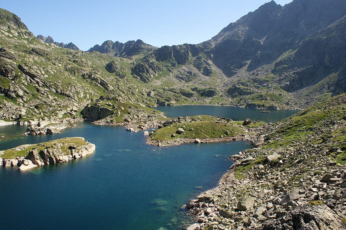
Estany de Cabana Sorda gets far fewer visitors than Juclar, which is odd, because the lake is arguably prettier – a dark oval jammed into a rock cirque at around 2,290 m with a small unstaffed refuge on the shore.
It is also the sharpest climb in the valley. The path leaves from the Comellassos spring roughly halfway along the Incles road, goes straight into the Pinosa pine forest, follows a ravine, and gains around 470 m in only about 2.8 km. That is a serious gradient by Andorran standards. Allow two to two and a half hours up and take poles if your knees have opinions.
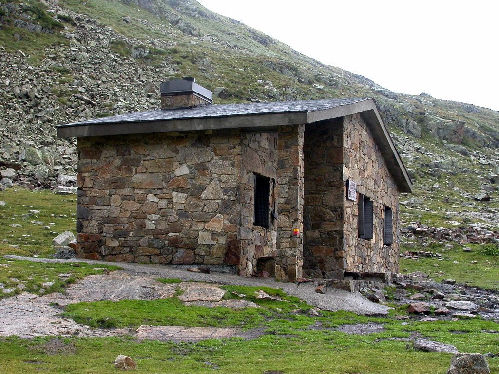
The refuge dates from 1981, sleeps about twenty, has a fireplace and basic bunks, and is open year-round because nobody staffs it. Take everything you need, leave it cleaner than you found it, and be aware that on summer weekends it can be full of people who had the same idea.
Because the trailhead is on the road rather than at the top, this is the walk that punishes shuttle passengers who ride straight to the end. Ask the driver to let you off, or simply walk back down the road for ten minutes.
Siscaro: the quiet alternative
Take the right-hand branch at the Travenc junction and you climb beside the stream into the Siscaro valley, a broader, greener hanging valley that ends at a series of tarns and boggy pools rather than one big lake. Figure on around 3.6 km and 500 m of ascent to the first proper lake, which is medium effort and a good deal less trafficked than Juclar.
There is an unstaffed Refugi de Siscaro up here – a simple stone shelter of the type Andorra scatters through its high valleys rather than a hotel with a warden. It is a fine lunch stop and an emergency roof, and I would not plan to sleep in it in August without a backup.
The wildlife is better on this side. I have watched roe deer on the far slope, and the pools hold trout and the Pyrenean newt, a small amphibian that only survives in cold, clean high-mountain water. Look, do not handle.
Over the top: Port d’Incles and the Fontargente lakes
Keep going past Siscaro and the path climbs to the Port d’Incles, a border col, then drops into the French Ariege and the Etangs de Fontargente. It is a long day out and back – well over 15 km with a real pass in the middle – but it is one of the most satisfying walks in eastern Andorra and the scenery flips character completely once you cross the ridge.
Waymarking is good on both sides. Take a passport-equivalent ID out of habit, take far more water than the distance suggests, and start at first light. This is not a route to begin at ten in the morning in July.
Long-distance trails: GRP, HRP and hut-to-hut
Vall d’Incles is a node, not a dead end. The Refugi de Juclar sits on Andorra’s circular Coronallacs and multi-day trekking network, which strings the country’s staffed and unstaffed refuges into a route you can walk in about five to seven days. Juclar is one of its more comfortable nights.
The high-level Pyrenean traverse also comes through this corner of the range on its way between the Ariege and the Cerdanya, which is why in July you will occasionally meet someone in the valley with a very large pack and the thousand-yard stare of a walker on week four.
The practical upshot for a day visitor is that the paths here are properly built and properly signed. Andorra’s waymarking is better than most of its neighbours’ and the junctions carry timings in hours rather than kilometres, which is the more useful measure on this terrain.
The Ransol side valley, one turning earlier
If Incles is full – and it does happen – drive or walk a couple of kilometres west and go up Ransol instead. It is the next valley heading north off the same main road, narrower and less photogenic on the floor but with excellent walking above it, including routes up towards the Coms de Jan refuge and the high ground below the Pic de la Serrera.
Ransol has no shuttle and no closure, so you can drive it in August. It is my standard escape valve on a bank holiday weekend, and it links back into the same high-level network as Incles, so you can plan a two-valley loop if you are staying locally.
Horses, cattle and what actually lives up there
Those horses in my photograph are not decorative. Incles is still working pasture – Canillo’s farmers move horses and cattle up here for the summer under grazing rights that go back centuries, and the animals come down again in autumn. They are placid and used to walkers. Do not feed them, keep dogs on a lead near the herds, and shut gates.
The vegetation stacks in bands as you climb: black pine and birch low down, then rhododendron thickets that turn shocking pink in late June, then alpine turf and finally rock. Above the tree line, watch for alpine accentors, water pipits and the odd griffon vulture drifting the thermals along the ridge.
Marmots are widespread in the upper cirques and you will hear their alarm whistle long before you see one. Izard, the Pyrenean chamois, are around but shy – dawn and dusk on the steep ground, not midday beside the lake. Incles itself is not a designated nature park, which surprises people; the protection here is de facto, delivered by the road closure and by the fact that the parish still farms it.
Winter: snowshoes, silence and a much shorter day
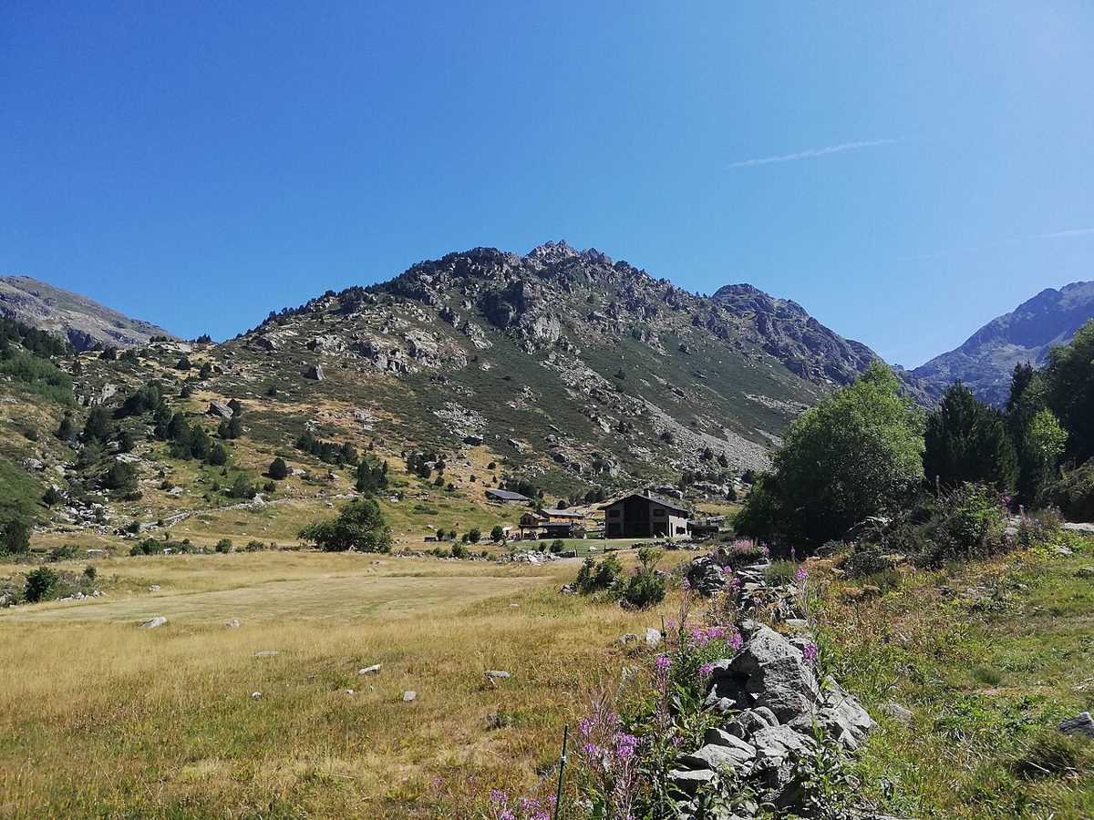
Incles in January is one of my favourite places in Andorra, partly because Grandvalira is roaring away three hundred metres below and almost nobody walks up here. The valley floor holds snow well, the gradient is negligible, and it is about as forgiving an introduction to snowshoeing as the Pyrenees offers.
The valley has also been used for cross-country and snowshoe circuits in some seasons, though what is groomed in a given winter varies and I would not travel specifically for it without checking first with the Canillo tourist office. Nordic skiing in Andorra is a small operation compared with the alpine resorts.
Three cautions, and I mean them. The road is not always driveable or open in winter conditions. The upper valleys above the Travenc junction are avalanche terrain and the Juclar and Cabana Sorda ascents are not casual winter objectives – people do them, with transceivers, shovels and judgement. And the light goes at about half past five in December, which arrives faster than you expect in a north-facing trough.
Planning your day
When to go
The lake paths are reliably clear of snow from late June to mid-October, though a late spring can leave old drifts on the Juclar approach into early July. Late June and the first half of July give you wildflowers and full rivers. September is my pick: the grass turns gold, the crowds evaporate after the first week, and the light is better for photographs.
August is the busy month, and if that is when you are coming, our guides to Andorra in August and Andorra in summer explain how to work around the crowds. For a month-by-month view of the whole country, see the best time to visit Andorra.
How long to allow
| Route | Distance, ascent and time |
|---|---|
| Valley floor to Travenc and back | About 4 km, negligible ascent, 1.5 hours |
| Juclar lakes and refuge | About 9-10 km return, 465 m, 4 hours plus stops |
| Cabana Sorda lake | About 5.5 km return, 470 m, 4 hours plus stops |
| Siscaro first lake | About 7 km return, 500 m, 4 hours plus stops |
| Port d’Incles and Fontargente | 15 km or more, 800 m or more, a full 7-9 hour day |
Those times assume a moderate pace with stops and no snow. Add a third if you are walking with young children, and subtract nothing for being fit – the altitude does take a small toll if you arrived from sea level that morning.
What to bring
Proper footwear with ankle support for anything above the meadow, because the upper paths are rocky and the descents are where people turn ankles. Two litres of water per person: there are streams but I would filter. Sun protection, because at 2,300 m the sun is fierce even when the air is cool.
A warm layer and a waterproof, always. I have been driven off the Juclar plain by a hail squall that arrived in fifteen minutes from a clear sky. Our Andorra packing list has the full summer and winter kit.
What it costs
The walking is free. The shuttle is around EUR 3 each way, the entrance car park a few euros for the day, and the bus from Andorra la Vella a few euros more. A bed and dinner at a staffed refuge like Juclar runs to a few tens of euros. A day in Incles is the cheapest good day you will have in this country, which is not a sentence you get to write about Andorra often.
With children
The flat valley floor is superb for kids: level ground, a shallow river, horses, and stone barns to inspect. The Canillo tourist office also runs a family treasure-hunt game specific to this valley, with a handful of marked itineraries, a leaflet you collect from the office and a small prize at the end. Ask for it by name at the Canillo or Incles office.
Under about eight, stop at Travenc. Eight to twelve with some hill experience will manage Juclar as a big day out. Cabana Sorda is too steep for most young legs. There is more on family-friendly Canillo in our guide to Canillo, the parish that owns all of this.
Mistakes I see people make here
Arriving at eleven in August. The car park is full, the shuttle queue is twenty minutes, and you have lost the coolest three hours of the day. Come at eight or come at four.
Riding the shuttle to the top when their target is Cabana Sorda, then walking back down the road annoyed. Know which trailhead you need before you buy a ticket.
Underestimating the weather. This valley sits directly on the French border ridge, and border ridges make their own afternoon storms in July and August. Be off the high ground by two if the sky is stacking up.
Treating the refuges as guaranteed accommodation. Juclar is staffed and bookable in summer only; Cabana Sorda is a shelter, not a hotel, and it can be full.
My honest verdict
Vall d’Incles is the most beautiful valley floor in Andorra and I would send any first-time visitor here before anywhere else. It gives you a genuine high-Pyrenean day with almost no barrier to entry – no exposure, no route-finding, a bus that gets you there and a shuttle that drops you at the meadow.
It is not the wildest place in the country, and it is not the most spectacular. For raw scale go up Coma Pedrosa, the highest peak in Andorra. For an unspoilt cultural landscape with no road at all, walk the UNESCO-listed Madriu-Perafita-Claror valley. For three lakes in half a day with less effort than Juclar, the Tristaina lakes in the north-west are hard to beat, and for wildflowers nothing in the country touches Sorteny.
What Incles has that none of those have is that flat green floor with the horses on it, ten minutes from a car park. That is worth a day of anyone’s holiday.
Frequently asked questions
Where exactly is Vall d’Incles?
It runs north from the CG-2 main road in the parish of Canillo, between El Tarter and Soldeu in eastern Andorra. The turning is signed and sits at around 1,750 m. From Andorra la Vella it is roughly 25 km and a 30 to 40 minute drive, or a similar journey by public bus up the Valira d’Orient valley.
Can you drive into Vall d’Incles?
Outside peak summer, yes, and you can park free at the road head. In high season – broadly mid-June to mid-September – private vehicles are barred during the day, typically between about 10:00 and 18:00. You park in the paid car park at the valley entrance and take the electric shuttle up instead.
How much does the Vall d’Incles shuttle cost?
Around EUR 3 each way in recent seasons, with young children usually free. It has run daily through the summer months from roughly 09:00 to 18:00, and the trip takes five to ten minutes. Prices and hours change annually, so confirm with the Canillo tourist office or Visit Andorra before you rely on the last departure.
How long does the Juclar lakes hike take?
Around two hours up and 90 minutes down, covering about 4.6 km each way with 465 m of ascent from the road head. Most people take four to five hours including a stop at the refuge. It is a moderate walk on a good path, not a technical one, but the last section is steep and loose.
What is the largest lake in Andorra?
Estany Primer de Juclar, at the head of the Vall d’Incles, at roughly 21 hectares and about 2,300 m altitude. A second Juclar lake lies immediately beyond it. The Refugi de Juclar sits on the shore at around 2,310 m and is staffed through the summer season.
Is Vall d’Incles good for families with young children?
Very. The first kilometre and a half from the Bordes d’Incles is flat, wide and beside a shallow river, with grazing horses and stone barns to look at. The Canillo tourist office runs a family treasure-hunt game in the valley with several marked routes and a prize at the end. The lake climbs suit older children only.
Can you get to Vall d’Incles by public transport?
Yes. National bus lines from Andorra la Vella towards Soldeu and Pas de la Casa stop at the mouth of the Incles road, roughly 30 to 40 minutes from the capital. From the stop it is a short walk to the shuttle car park. Check current line numbers and timetables before travelling, as the network gets renumbered.
Is it worth visiting in winter?
For snowshoeing on the valley floor, yes – it is quiet, flat and beautiful, with Grandvalira’s crowds entirely out of sight. The higher lake routes are avalanche terrain and need winter skills and equipment. Check road access first, because the valley road is not always open or driveable in snow.
Related guides
Start with our pillar guide to hiking in Andorra for the full trail picture, then compare Incles with the easy classic at Lake Engolasters above the capital. If you are building a whole trip around walking, our Andorra summer itinerary puts the valleys in a sensible order.
Photo credits
All photographs are from Wikimedia Commons under their stated licences, with thanks to the photographers:


